Nature— autumn
Mount Bandai and Urabandai: Fukushima's Volcano and Its Aftermath
July 3, 2026
Mount Bandai is a living volcano with two faces. This guide covers Mt Bandai hiking, the 1888 eruption that built the Urabandai plateau, and the lakes, foliage, and access that make Fukushima's signature peak worth the climb.
Mount Bandai has two faces. From the south, across the broad mirror of Lake Inawashiro, it rises in a clean, conical sweep that earns it the nickname Aizu Fuji, the Mount Fuji of the Aizu region. Walk to the other side and the picture collapses, literally. The northern flank is a raw amphitheatre of gouged rock and bare cliff, the scar of a single catastrophic morning in 1888 that rearranged the landscape and the lives around it.
That contrast is the whole story of the mountain. Bandai-san, roughly 1,816 metres high and still officially an active stratovolcano, sits at the heart of Bandai-Asahi National Park in northern Fukushima. Its gentle Omote, or front, face looks out toward one of Japan's largest lakes; its shattered Ura, or back, face presides over a plateau of pondsthat did not exist before the eruption. To hike Bandai is to walk between those two worlds in the course of a single day.
Aizu Fuji: The Mountain and Its Identity
Bandai dominates the Aizu basin the way few mountains dominate anything. There is little to obstruct it. Lake Inawashiro spreads flat and wide to the south, and the volcano lifts almost straight out of the surrounding farmland, giving it a presence out of proportion to its modest elevation. The conical southern profile is what earned the Aizu Fuji label, and on still mornings the peak doubles itself in the lake's surface in the manner that has made the original Fuji famous.
The mountain has long been woven into local life as a landmark, a weather indicator, and an object of reverence. Shrines and old pilgrimage associations attach to it, as they do to most prominent Japanese peaks, and its name appears across the region on everything from sake labels to railway lines. But Bandai is not a single tidy summit. It is a cluster of peaks and craters, the product of repeated volcanic activity over many thousands of years, and the highest point, Obandai, is only one node in a more complicated massif. Understanding that the mountain is a working volcano rather than a finished monument is the key to reading what hikers encounter on its slopes.
The 1888 Eruption and the Birth of Urabandai
On the morning of 15 July 1888, the mountain's northern peak, Kobandai, destroyed itself. The event was a phreatic eruption, driven by superheated steam rather than fresh lava, and it culminated in a violent collapse of the upper north flank. A debris avalanche surged down the slope, burying villages and damming the rivers and streams below. The disaster killed roughly 477 people, one of the deadliest volcanic events in Japan's modern history.
The aftermath reshaped the terrain permanently. With the valleys blocked by avalanche debris, water pooled into a scatter of new lakes and ponds across the newly chaotic ground to the north. That landscape became known as Urabandai, the back of Bandai, and over the following decades it transformed from a sterile grey wasteland into one of the lushest corners of the national park. Reforestation, much of it deliberate, clothed the debris field in birch and broadleaf woodland, and the dammed waters settled into the marshy, pond-strewn plateau visitors see today.
Goshikinuma, the Five Coloured Ponds
The most celebrated of these new waters is Goshikinuma, a chain of small ponds whose surfaces range from cobalt and turquoise to a milky jade green. The colours come from dissolved volcanic minerals and the way light scatters through them, and they shift with the weather, the season, and the angle of the sun. A gentle walking trail of a few kilometres threads between the ponds through quiet woodland, an easy counterpoint to the summit climb and one of the clearest illustrations anywhere of how an act of destruction produced something of unexpected beauty.
Mt Bandai Hiking: Routes to the Summit
Nature
Goshikinuma: Fukushima's Five Colored Ponds
A cluster of volcanic ponds in northern Fukushima glows turquoise, cobalt, and emerald — colors born from a single catastrophic eruption. A guide to walking Goshikinuma and reading its strange chemistry.
Mt Bandai hiking is among the most popular day climbs in southern Tohoku, and for good reason. The summit is reachable and back within a single day by several routes of differing effort, the trails are well established, and the payoff is a panorama that takes in both of the mountain's faces at once. The catch is that none of the routes are trivial; this is a real mountain with steep sections, loose volcanic ground, and weather that can turn quickly.
The Happodai Route from the Bandai Goldline
The most direct and frequently walked approach starts high on the southern side, from the Happodai trailhead reached via the Bandai-Goldline toll road. Because the road has already carried walkers well up the mountain, this route minimises the total ascent and is the usual choice for those wanting a straightforward up-and-down day. The path climbs through forest before opening onto more exposed volcanic slopes near the top, and a mountain hut below the summit offers a place to rest and refill before the final push.
The Urabandai and Kawakami Routes
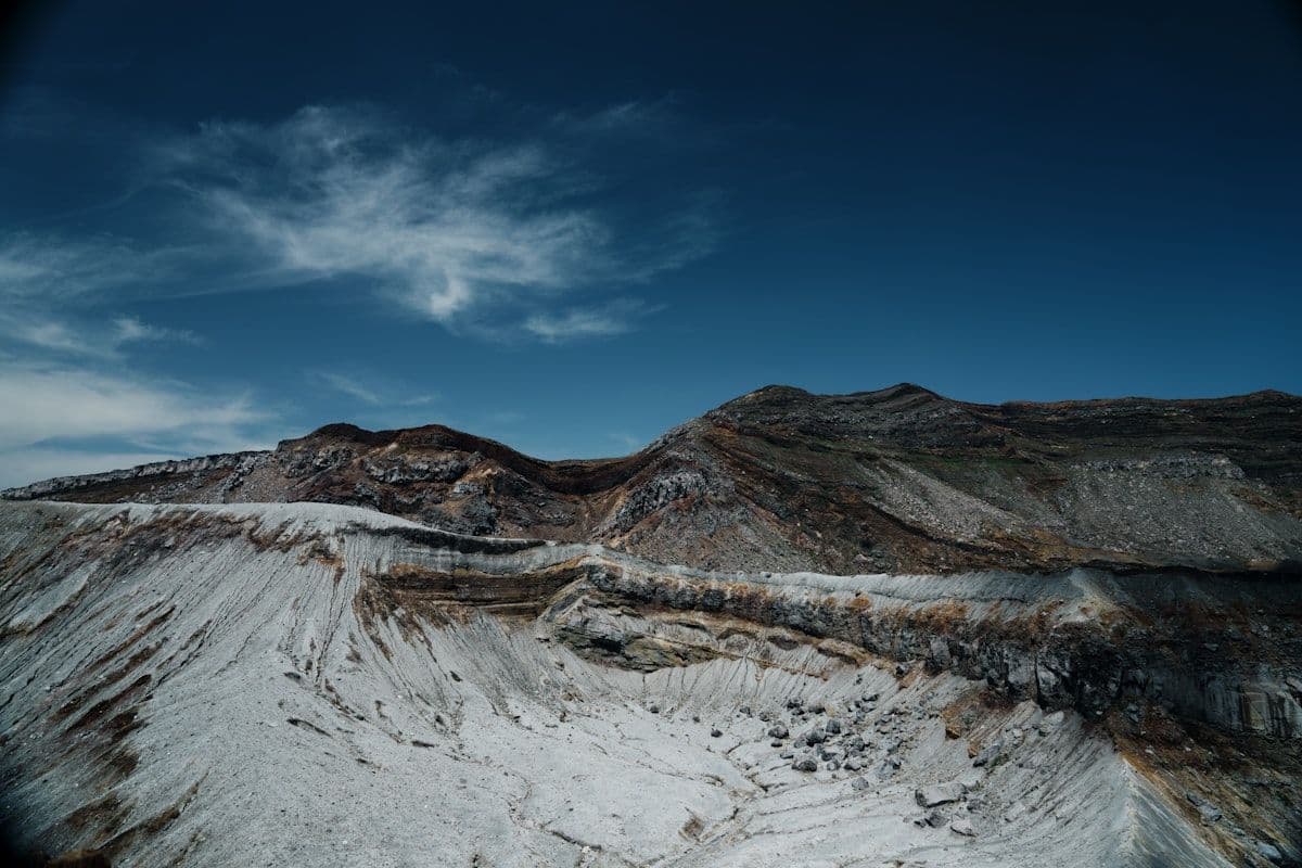
From the northern side, trails ascend out of the Urabandai plateau, and these are the routes that deliver the mountain's most dramatic scenery. Walkers climb past the great collapsed crater wall left by the 1888 eruption, an immense curving cliff of bare rock that makes the scale of the catastrophe physically legible. The Kawakami trail and other northern approaches involve more total climbing than the Goldline route and are correspondingly quieter, rewarding the extra effort with the rawest views on the mountain. Some hikers ascend from one side and descend the other, given suitable transport arrangements, to experience the full contrast of Omote and Ura in one traverse.
What You See from the Top
The summit view is the reason people come. To the south, Lake Inawashiro fills the foreground, vast and pale, with the Aizu plain beyond it and ranks of mountains on the far horizon. To the north, the eye drops into the green, pond-dotted sprawl of Urabandai, the lakes glinting among the trees. In autumn the slopes below catch fire, the broadleaf forest turning gold and crimson, and the combination of foliage, lake, and the stark grey crater makes the climb at its most memorable. Peak colour typically arrives in October.
Beyond the Summit: Lakes, Ponds, and Snow
The area rewards visitors who treat the summit as one stop among several. Lake Inawashiro, on the southern side, is among the largest lakes in Japan and a destination in its own right, with swimming and watersports in summer and flocks of wintering swans along its shores in the cold months. Its open water gives the classic reflected view of Aizu Fuji.
On the northern side, beyond Goshikinuma, Urabandai holds a constellation of larger lakes, Hibara among them, with cycling paths, boat rentals, campgrounds, and quiet trails that make the plateau a low-key base for several days. For those interested in the human side of the 1888 disaster, the Bandaisan Erupting Memorial Museum interprets the eruption and its consequences, grounding the scenery in the event that created it. When winter closes in, the same slopes that draw hikers in autumn become ski terrain, with resorts on and around the mountain operating through the snow season.
Seasons, Access, and Practical Tips
Bandai keeps a clear seasonal rhythm. Summer brings green slopes and the most reliable hiking conditions, though afternoon thunderstorms are common. Autumn, particularly October, is the headline season, when the foliage peaks and the air is crisp and clear. Winter buries the high ground in deep snow and shifts the focus to skiing; the summit trails are then the domain of experienced winter mountaineers only. Spring is a transitional shoulder season, with snow lingering high into the warmer months.
Access is straightforward by Tohoku standards. Trains on the Banetsu West Line run to Inawashiro Station from both Koriyama, on the Tohoku Shinkansen, and Aizu-Wakamatsu. From Inawashiro Station, seasonal and regular buses serve the trailheads, the Goldline, and the Urabandai lakes, though schedules thin out sharply outside the main season, so checking timetables in advance is essential. A car offers far more flexibility, especially for reaching the higher trailheads and for moving between the southern and northern sides of the mountain.
As for the climb itself, ordinary mountain sense applies. Carry layers, water, and rain protection regardless of the forecast, start early to allow margin for changing weather, and wear footwear suited to loose volcanic ground. Because Bandai remains an active volcano, it is monitored, and walkers should heed any official advisories or trail closures. The mountain has been quiet for a long time, but the scar on its northern face is a standing reminder that quiet is not the same as finished.
Frequently Asked Questions
How long does it take to hike Mount Bandai?
It depends on the route. The shortest common approach, from the Happodai trailhead on the Bandai-Goldline, can be completed as a round trip in roughly four to five hours at a steady pace, including stops. The northern routes from Urabandai involve more total climbing and take longer. In all cases it is a full day-hike rather than a casual stroll, so an early start and a realistic turnaround time are wise.
What is the difference between Bandai and Urabandai?
Bandai refers to the mountain and, loosely, its gentle southern Omote face overlooking Lake Inawashiro. Urabandai, meaning the back of Bandai, is the plateau on the northern side created by the 1888 eruption, characterised by collapsed crater scenery and a scatter of lakes and ponds, including Goshikinuma. The two sides offer very different experiences: one serene and conical, the other raw and dramatic.
When is the best time to visit Mount Bandai?
October is the standout month, when autumn foliage peaks across the slopes and the views over Inawashiro and the Urabandai lakes are at their richest. Summer is reliable for hiking and lake activities, while winter transforms the area into ski terrain. The summit trails are best left to experienced mountaineers once snow arrives.
Is Mount Bandai still an active volcano?
Yes. Mount Bandai is classified as an active stratovolcano and is monitored accordingly, though it has not erupted significantly since the catastrophic 1888 event. Hikers should check for any current advisories before setting out and observe trail closures, but under normal conditions the mountain is a safe and rewarding climb.